This post gives a very brief introduction to the best Lulworth Cove walks. All the walks start in the main car park at Lulworth Cove Sat Nav postcode BH20 5RQ (Google map). Car park charges are £5 for 4 hours which is sufficient for most walks, or £10 all day. For more detailed visitor information see https://www.dorsetguide.com/lulworth-cove/
For each walk I’ve included a quick route description and a low resolution map. I’ve also included a link to the Outdooractive.com site where you can view a high quality interactive GPS route map for each walk. This allows you to follow the route in real time on your phone although an internet connection is required. This is completely free and no membership is required. If you download the Outdooractive App for your phone you can also view the maps there and follow the routes for free. The only advantage of signing up to a paid membership level is that you can save the route maps to your phone and navigate the walks without an internet connection. I’ve also included a link to the same route map in Alltrails.com which is very similar to Outdooractive which some people may prefer. A Google map link also shows the routes although the Google base map isn’t very detailed and not really suitable for hiking.
Some walks have links to posts within this website which include a more detailed route description and plenty of my own photos. Over the next few months I’ll add many more such posts but for the time-being I hope just a route map will be sufficient to inspire you to get yourself down to Lulworth Cove and enjoy some of the fantastic walks that this stunning region has to offer.
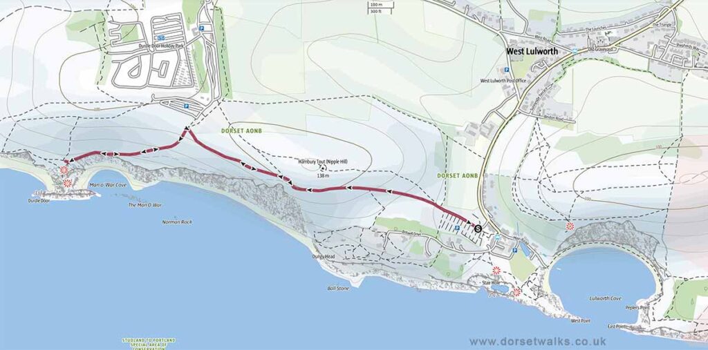
1. Lulworth Cove to Durdle Door Walk (out & back)
Distance: 2.1 miles (circular)
Difficulty: Easy
Estimated time: 1 hour 10 minutes
Total ascent 659ft, Highest point 410ft
OS Map: Explorer OL15 Purbeck & South Dorset
*** Route description and photos ***
Link to GPS route map
https://www.outdooractive.com/
https://www.alltrails.com/
https://explore.osmaps.com/
https://www.google.com/maps/
Base map © OpenStreetMap
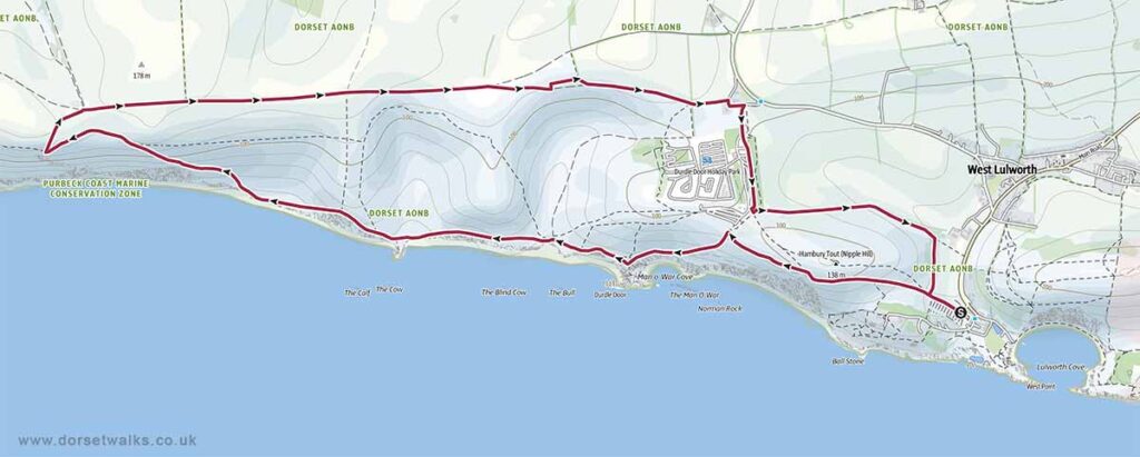
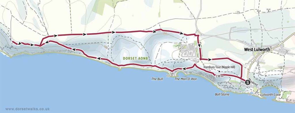
2. Lulworth Cove to Durdle Door & West Bottom Walk
Distance: 6.3 miles (circular)
Difficulty: Moderate
Estimated time: 3 hours 20 minutes
Total ascent 1358ft, Highest point 554ft
OS Map: Explorer OL15 Purbeck & South Dorset
Link to GPS route map
https://www.outdooractive.com/
https://www.alltrails.com/
https://explore.osmaps.com/
https://www.google.com/maps/
Base map © OpenStreetMap
3. Lulworth Cove to Durdle Door & White Nothe Walk
Distance: 7 miles (circular)
Difficulty: Moderate
Estimated time: 3 hours 40 minutes
Total ascent 1358ft, Highest point 554ft
OS Map: Explorer OL15 Purbeck & South Dorset
*** Route description and photos ***
Link to GPS route map
https://www.outdooractive.com/
https://www.alltrails.com/
https://explore.osmaps.com/
https://www.google.com/maps/
Base map © OpenStreetMap
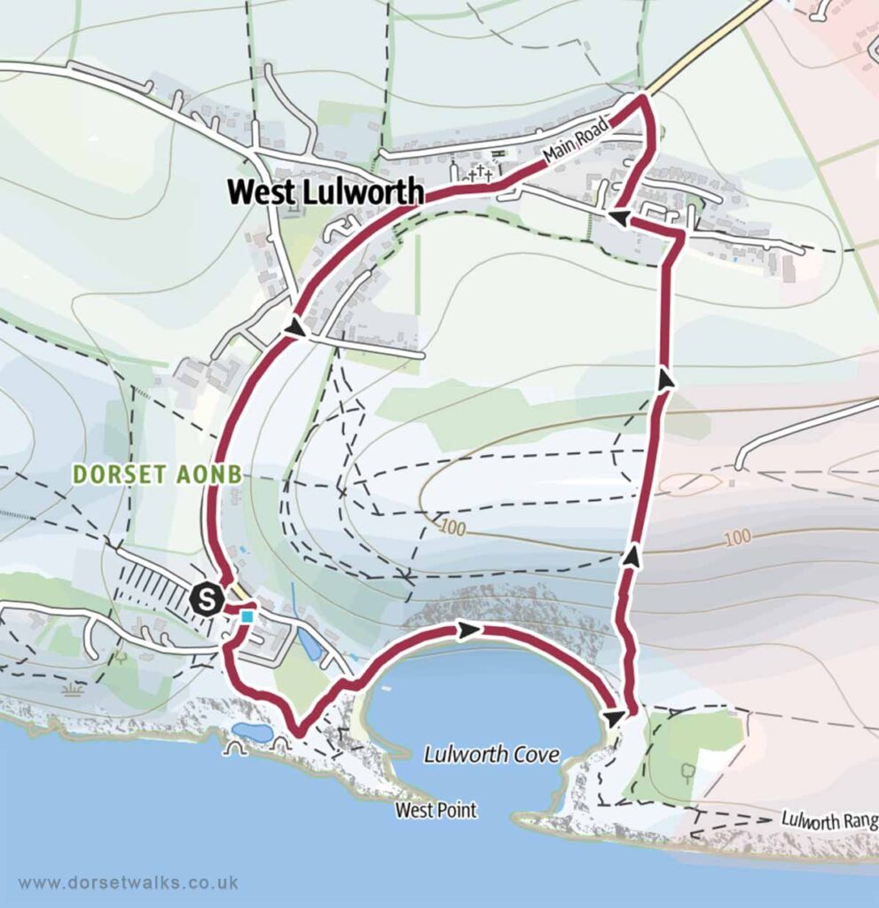
4. Lulworth Cove Beach & West Lulworth Village Walk
Distance: 2.2 miles (circular)
Difficulty: Easy
Estimated time: 1 hour 10 minutes
Total ascent 614ft, Highest point 430ft
OS Map: Explorer OL15 Purbeck & South Dorset
Link to GPS route map
https://www.outdooractive.com/
https://www.alltrails.com/
https://explore.osmaps.com/
https://www.google.com/maps/
Base map © OpenStreetMap
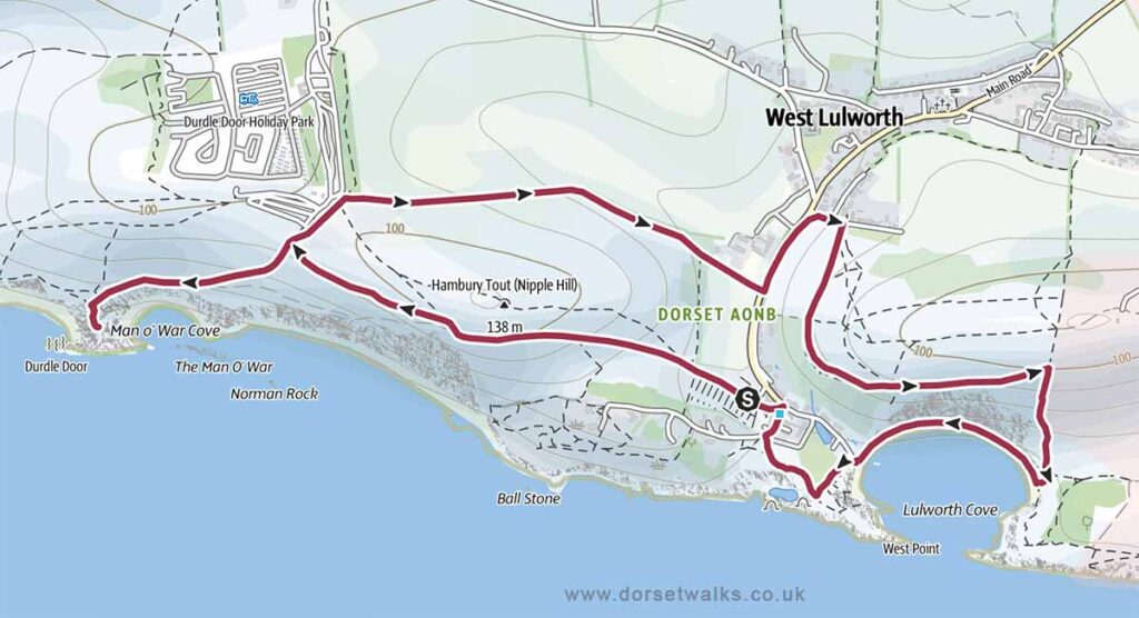
5. The Best of Lulworth Cove and Durdle Door Walk
Distance: 3.9 miles (circular)
Difficulty: Easy
Estimated time: 2 hours 10 minutes
Total ascent 1001ft, Highest point 410ft
OS Map: Explorer OL15 Purbeck & South Dorset
This is one of the best Lulworth Cove walks and one of my favourite walks in Dorset. I never get bored of walking this route and the coastal views are absolutely stunning taking in two of Dorset’s most iconic landmarks: Lulworth Cove and Durdle Door.
Link to GPS route map
https://www.outdooractive.com/
https://www.alltrails.com/
https://explore.osmaps.com/
https://www.google.com/maps/
Base map © OpenStreetMap
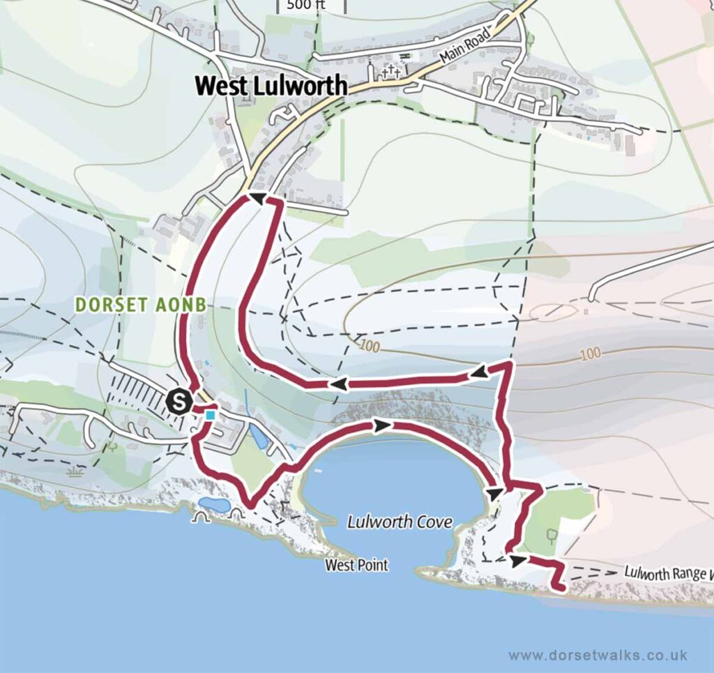
6. Lulworth Cove Beach & Fossil Forest Walk
Distance: 2.3 miles (circular)
Difficulty: Easy
Estimated time: 1 hour 15 minutes
Total ascent 436ft, Highest point 374ft
OS Map: Explorer OL15 Purbeck & South Dorset
The Fossil Forest lies within the Lulworth Firing Range and can only be visited when the range is open which is usually most weekends and school holidays. However, to avoid disappointment, it’s always best to check opening dates in advance on the government website https://www.gov.uk/
Link to GPS route map
https://www.outdooractive.com/
https://www.alltrails.com/
https://explore.osmaps.com/
https://www.google.com/maps/
Base map © OpenStreetMap
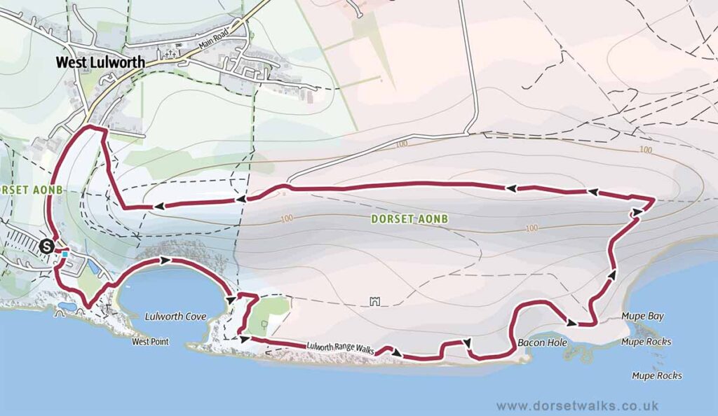
7. Lulworth Cove Beach & Mupe Bay Walk
Distance: 4 miles (circular)
Difficulty: Easy
Estimated time: 2 hours
Total ascent 610ft, Highest point 548ft
OS Map: Explorer OL15 Purbeck & South Dorset
Mupe Bay lies within the Lulworth Firing Range and can only be visited when the range is open which is usually most weekends and school holidays. However, to avoid disappointment, it’s always best to check opening dates in advance on the government website https://www.gov.uk/
Link to GPS route map
https://www.outdooractive.com/
https://www.alltrails.com/
https://explore.osmaps.com/
https://www.google.com/maps/
Base map © OpenStreetMap
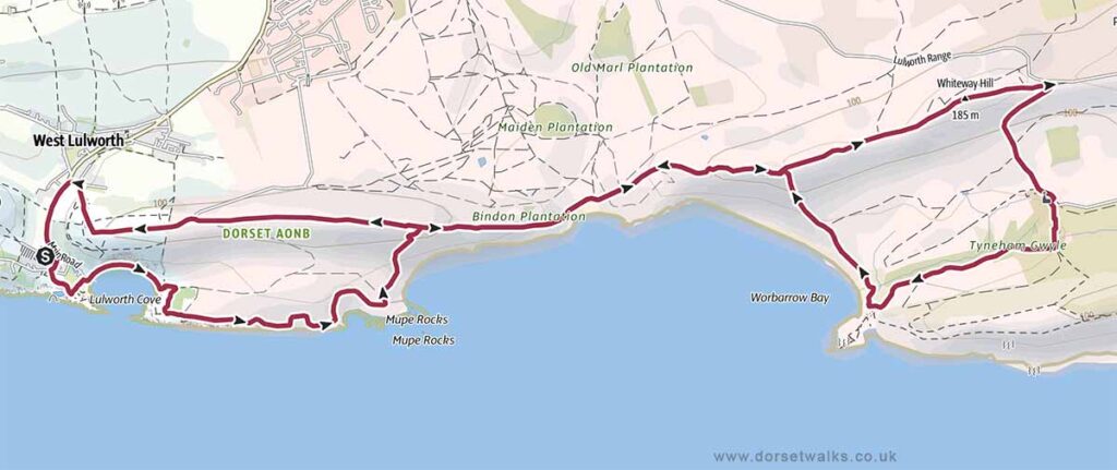
8. Lulworth Cove to Mupe Bay, Wobarrow Bay & Tyneham Village
Distance: 10.1 miles (circular)
Difficulty: Moderate to Strenuous
Estimated time: 5 hours 15 minutes
Total ascent 2188ft, Highest point 610ft
OS Map: Explorer OL15 Purbeck & South Dorset
Mupe Bay, Wobarrow Bay and the village of Tyneham all lie within the Lulworth Firing Range and can only be visited when the range is open which is usually most weekends and school holidays. However, to avoid disappointment, it’s always best to check opening dates in advance on the government website https://www.gov.uk/
Link to GPS route map
https://www.outdooractive.com/
https://www.alltrails.com/
https://explore.osmaps.com/
https://www.google.com/maps/
Base map © OpenStreetMap
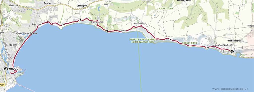
9. Lulworth Cove to Weymouth Walk (South West Coast Path)
Distance: 11.3 miles (one-way)
Difficulty: Moderate to Strenuous
Estimated time: 5 hours 45 minutes
Total ascent 1867ft, Highest point 538ft
OS Map: Explorer OL15 Purbeck & South Dorset
Link to GPS route map
https://www.outdooractive.com/
https://www.alltrails.com/
https://explore.osmaps.com/
https://www.google.com/maps/
Base map © OpenStreetMap
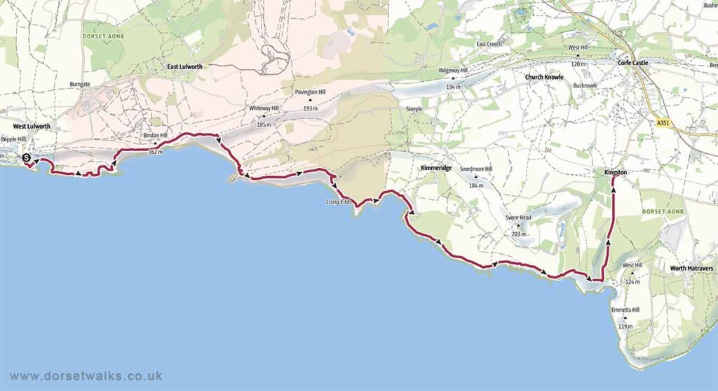
10. Lulworth Cove to Kingston Walk (South West Coast Path)
Distance: 12.4 miles (one-way)
Difficulty: Strenuous
Estimated time: 7 hours 5 minutes
Total ascent 2579ft, Highest point 561ft
OS Map: Explorer OL15 Purbeck & South Dorset
The section of the South West Coast Path between the east of Lulworth Cove and the west of Kimmeridge lies within the Lulworth Firing Range and can only be visited when the range is open which is usually most weekends and school holidays. However, to avoid disappointment, it’s always best to check opening dates in advance on the government website https://www.gov.uk/
Link to GPS route map
https://www.outdooractive.com/
https://www.alltrails.com/
https://explore.osmaps.com/
https://www.google.com/maps/
Base map © OpenStreetMap