
The Best Wareham Walks includes 11 country and riverside walks starting in the historic market town of Wareham. Wareham is located between the River Piddle and the River Frome 8 miles southwest of Poole and 6 miles northwest of Corfe Castle. Wareham has a lovely riverside Quay in close proximity to excellent pubs and restaurants. It is frequently referred to as the “Gateway to the Isle of Purbeck”.
Wareham Town centre parking can be found at:
Wareham Quay Car Park (short stay and busy)
BH20 4LP (Google map)(what3words)
Streche Road Car Park Wareham
BH209 4QF (Google map)(what3words)
This is the largest town centre car park and suitable for all day walks to Corfe Castle etc. Car park fees £1.50 up to 2 hours, £3.50 up to 4 hrs, £6 all day (subject to change). More details and parking fees see https://www.dorsetcouncil.gov.uk/
Connegar Lane Car Park Wareham
BH20 4NQ (Google map)(what3words)
This is a small car park accessed by narrow roads around the back of St Marys Priory and is convenient for the Wareham Two Rivers Walk. Car park fees £1.50 up to 2 hours, £3.50 up to 4 hrs, £6 all day (subject to change). More details and parking fees see https://www.dorsetcouncil.gov.uk/
Wareham is served by regular buses to Poole, Corfe Castle, Kingston and Swanage (Purbeck Breezer 40 service https://www.morebus.co.uk/)
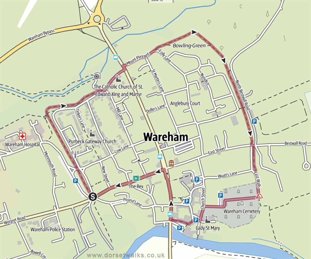
1. Wareham Town Walls Walk
Distance: 1.6 miles (circular)
Difficulty: Easy
Estimated time: 40 minutes
Total ascent 85 ft, Highest point 43 ft
Starting point: Streche Road Car Park, Wareham, BH209 4QF
OS Map: Explorer OL15 Purbeck & South Dorset
More info: https://www.dorsetcouncil.gov.uk/
Link to GPS route map
https://www.outdooractive.com/
https://www.alltrails.com/
https://explore.osmaps.com/
Base map © OpenStreetMap
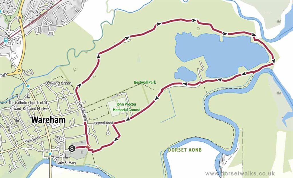
2. Wareham Two Rivers Walk
Distance: 3.1 miles (circular)
Difficulty: Easy
Estimated time: 1 hour 15 minutes
Total ascent 56 ft, Highest point 20 ft
Starting point: Connegar Lane Car Park, Wareham, BH20 4NQ
OS Map: Explorer OL15 Purbeck & South Dorset
More info: https://www.dorsetcouncil.gov.uk/
Link to GPS route map
https://www.outdooractive.com/
https://www.alltrails.com/
https://explore.osmaps.com/
Base map © OpenStreetMap
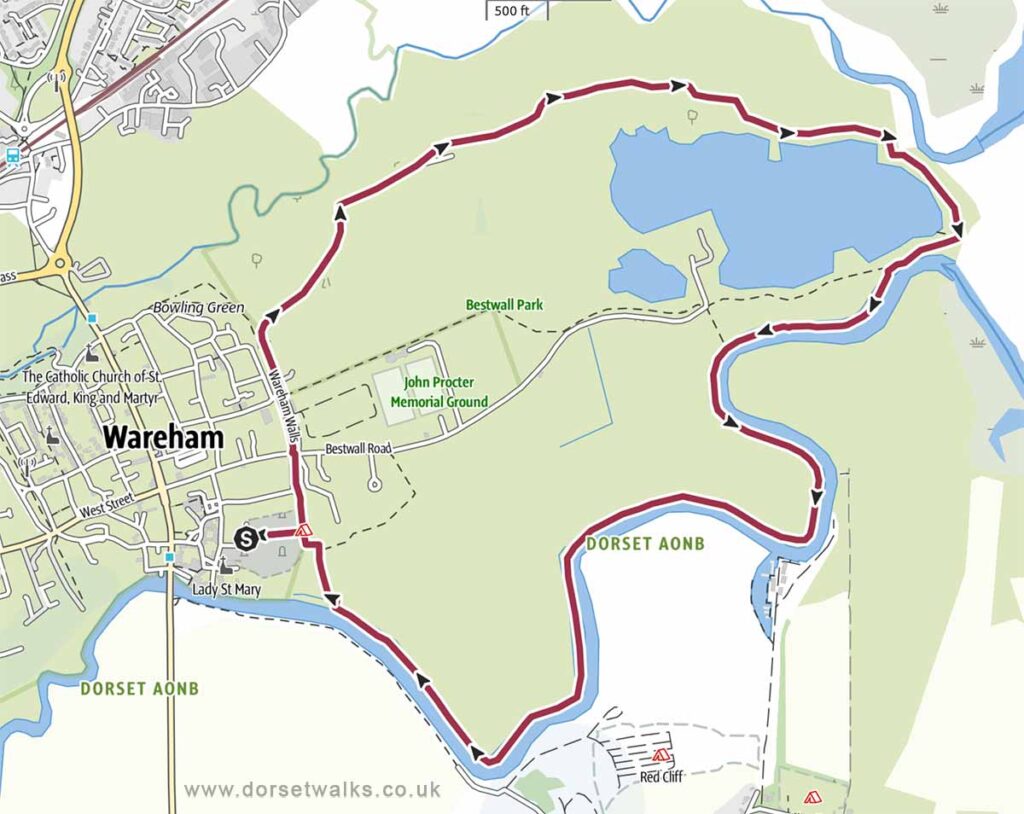
3. Wareham Two Rivers Extended Walk
Distance: 3.9 miles (circular)
Difficulty: Easy
Estimated time: 1 hours 30 minutes
Total ascent 56 ft, Highest point 20 ft
Starting point: Connegar Lane Car Park, Wareham, BH20 4NQ
OS Map: Explorer OL15 Purbeck & South Dorset
Link to GPS route map
https://www.outdooractive.com/
https://www.alltrails.com/
https://explore.osmaps.com/
Base map © OpenStreetMap
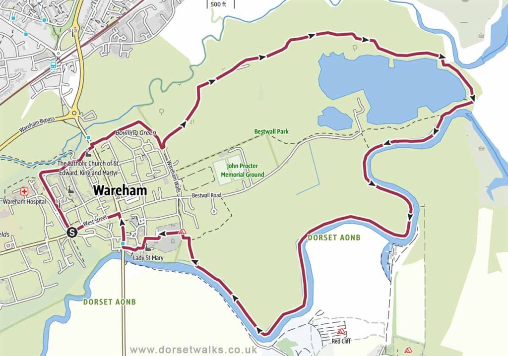
4. Wareham Town Walls and Rivers Walk
Distance: 4.6 miles (circular)
Difficulty: Easy
Estimated time: 1 hour 55 minutes
Total ascent 102 ft, Highest point 43 ft
Starting point: Streche Road Car Park, Wareham, BH209 4QF
OS Map: Explorer OL15 Purbeck & South Dorset
Link to GPS route map
https://www.outdooractive.com/
https://www.alltrails.com/
https://explore.osmaps.com/
Base map © OpenStreetMap
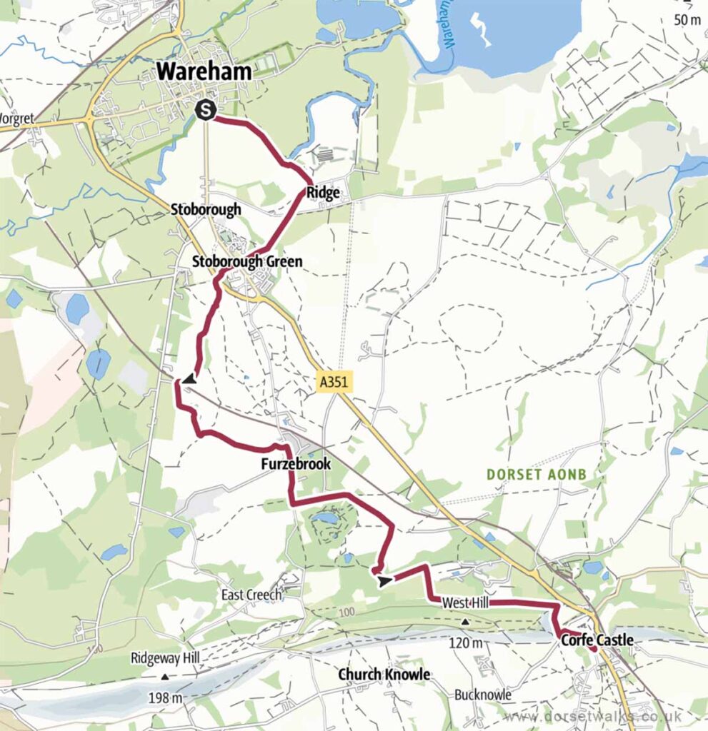
5. Wareham to Corfe Castle along The Purbeck Way (one-way)
Distance: 6.3 miles (one-way)
Difficulty: Easy
Estimated time: 2 hours 40 minutes
Total ascent 262 ft, Highest point 226 ft
Starting point: Wareham Bridge (by the Quay), BH20 4LP
OS Map: Explorer OL15 Purbeck & South Dorset
More info: https://www.dorsetcouncil.gov.uk/
Link to GPS route map
https://www.outdooractive.com/
https://www.alltrails.com/
https://explore.osmaps.com/
Base map © OpenStreetMap
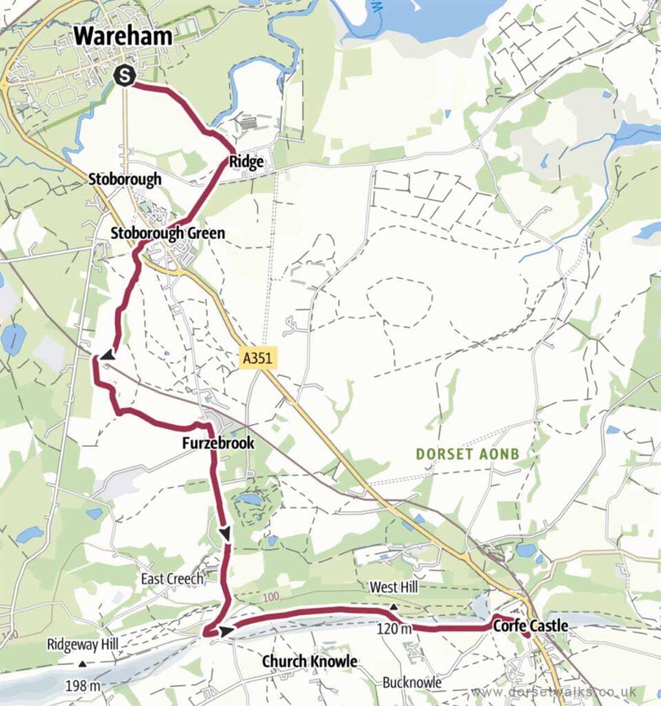
6. Wareham to Corfe Castle along The Hardy Way (one-way)
Distance: 6.5 miles (one-way)
Difficulty: Easy
Estimated time: 2 hours 50 minutes
Total ascent 518 ft, Highest point 479 ft
Starting point: Wareham Bridge (by the Quay), BH20 4LP
OS Map: Explorer OL15 Purbeck & South Dorset
Link to GPS route map
https://www.outdooractive.com/
https://www.alltrails.com/
https://explore.osmaps.com/
Base map © OpenStreetMap
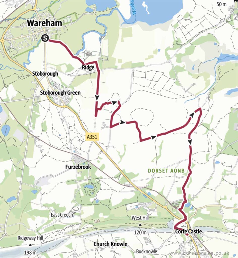
7. Wareham to Corfe Castle along the Poole Harbour Trail (one-way)
Distance: 7.3 miles (one-way)
Difficulty: Easy
Estimated time: 3 hours
Total ascent 125 ft, Highest point 85 ft
Starting point: Wareham Bridge (by the Quay), BH20 4LP
OS Map: Explorer OL15 Purbeck & South Dorset
More info: http://www.pooleharbourtrails.org.uk
Link to GPS route map
https://www.outdooractive.com/
https://www.alltrails.com/
https://explore.osmaps.com/
Base map © OpenStreetMap
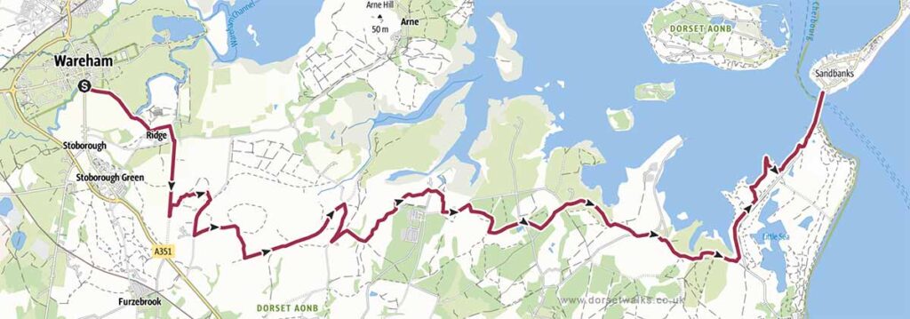
8. Wareham to Sandbanks along the Poole Harbour Trail (one-way)
Distance: 12.6 miles (one-way)
Difficulty: Moderate
Estimated time: 5 hours 5 minutes
Total ascent 125 ft, Highest point 85 ft
Starting point: Wareham Bridge (by the Quay), BH20 4LP
OS Map: Explorer OL15 Purbeck & South Dorset
More info: http://www.pooleharbourtrails.org.uk
Link to GPS route map
https://www.outdooractive.com/
https://www.alltrails.com/
https://explore.osmaps.com/
Base map © OpenStreetMap
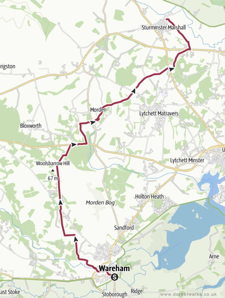
9. Wareham to Sturminster Marshall along the Wareham Forest Way (one-way)
Distance: 13 miles (one-way)
Difficulty: Moderate
Estimated time: 5 hours 15 minutes
Total ascent 354 ft, Highest point 289 ft
Starting point: Wareham Bridge (by the Quay), BH20 4LP
OS Map: Explorer OL15 Purbeck & South Dorset
More info: https://www.dorsetcouncil.gov.uk/
Link to GPS route map
https://www.outdooractive.com/
https://www.alltrails.com/
https://explore.osmaps.com/
Base map © OpenStreetMap
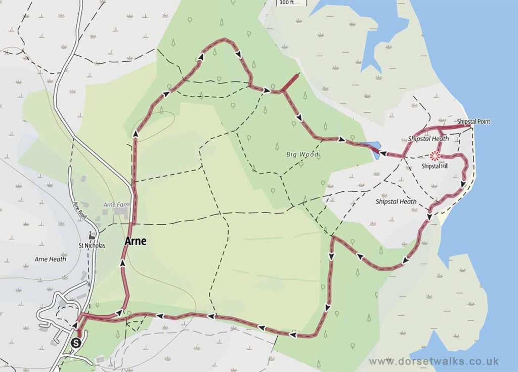
10. RSPB Arne Walk (Red Trail)
Distance: 2.6 miles (circular)
Difficulty: Easy
Estimated time: 1 hour 5 minutes
Total ascent 33 ft, Highest point 79 ft
Starting point: Wareham Bridge (by the Quay), BH20 4LP
OS Map: Explorer OL15 Purbeck & South Dorset
More info: https://www.rspb.org.uk/
Link to GPS route map
https://www.outdooractive.com/
https://www.alltrails.com/
https://explore.osmaps.com/
Base map © OpenStreetMap
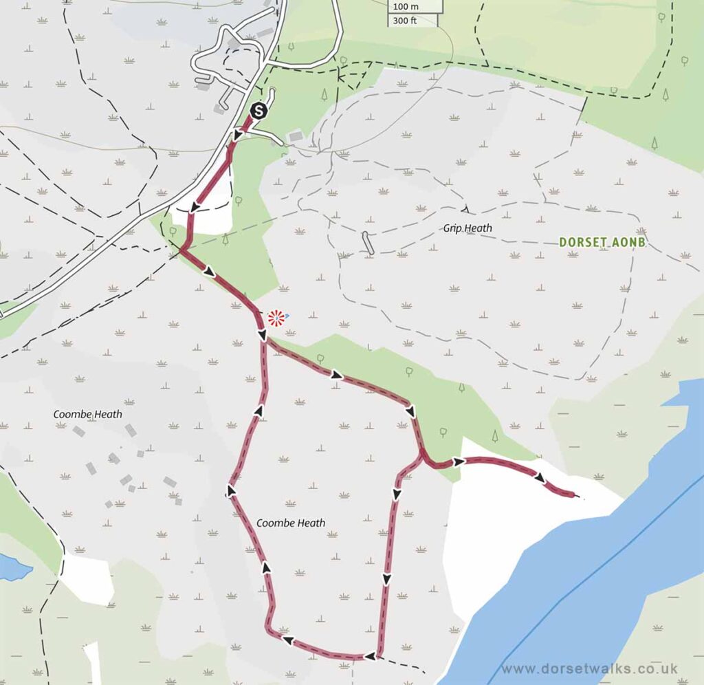
11. RSPB Arne Coombe Heath Walk
Distance: 1.9 miles (circular)
Difficulty: Easy
Estimated time: 45 minutes
Total ascent 43 ft, Highest point 49 ft
Starting point: Wareham Bridge (by the Quay), BH20 4LP
OS Map: Explorer OL15 Purbeck & South Dorset
More info: https://www.rspb.org.uk/
Link to GPS route map
https://www.outdooractive.com/
https://www.alltrails.com/
https://explore.osmaps.com/
Base map © OpenStreetMap