The Best Kingston Walks includes 12 superb walks starting in the small Purbeck village of Kingston which is located about 2 miles south of Corfe Castle and about 5 miles west of the popular seaside resort of Swanage. The village boasts an excellent pub – the Scott Arms – as well as the elaborate St James’ Church which resembles a miniature early English cathedral. The village is served by regular buses to Swanage, Corfe Castle, Wareham and Poole (Purbeck Breezer 40 service)
Walk highlights include routes to Corfe Castle, Swyre Head, Kimmeridge and Chapmans Pool.
Kingston Car Parks (both free of charge)
Sheep Pens Car Park (Swyre Head Car Park) BH20 5LP (Google map)(what3words)
Kingston Car Park (Houns-tout Car Park) BH20 5LL (Google map) (what3words)
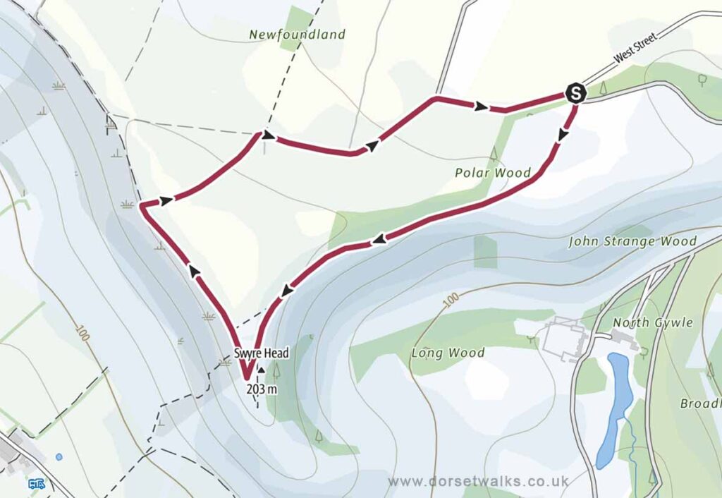
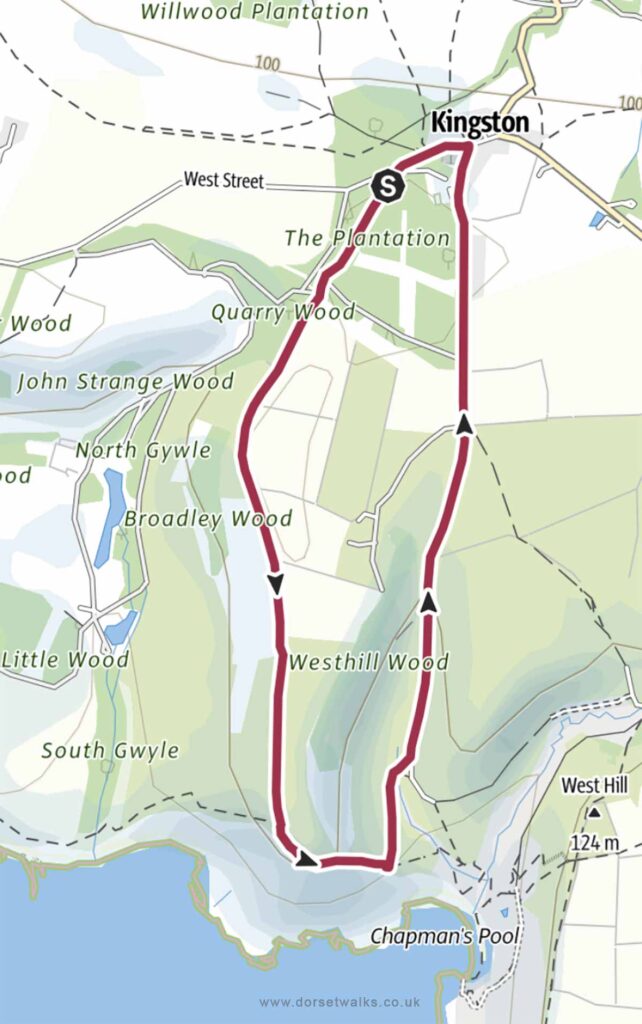
1. Kingston to Swyre Head Walk
Distance: 2 miles (circular)
Difficulty: Easy
Estimated time: 1 hour
Total ascent 207 ft, Highest point 667 ft
Starting point: Sheep Pens Car Park BH20 5LP
OS Map: Explorer OL15 Purbeck & South Dorset
Link to GPS route map
https://www.outdooractive.com/
https://www.alltrails.com/
https://explore.osmaps.com/
https://www.google.com/
Base map © OpenStreetMap
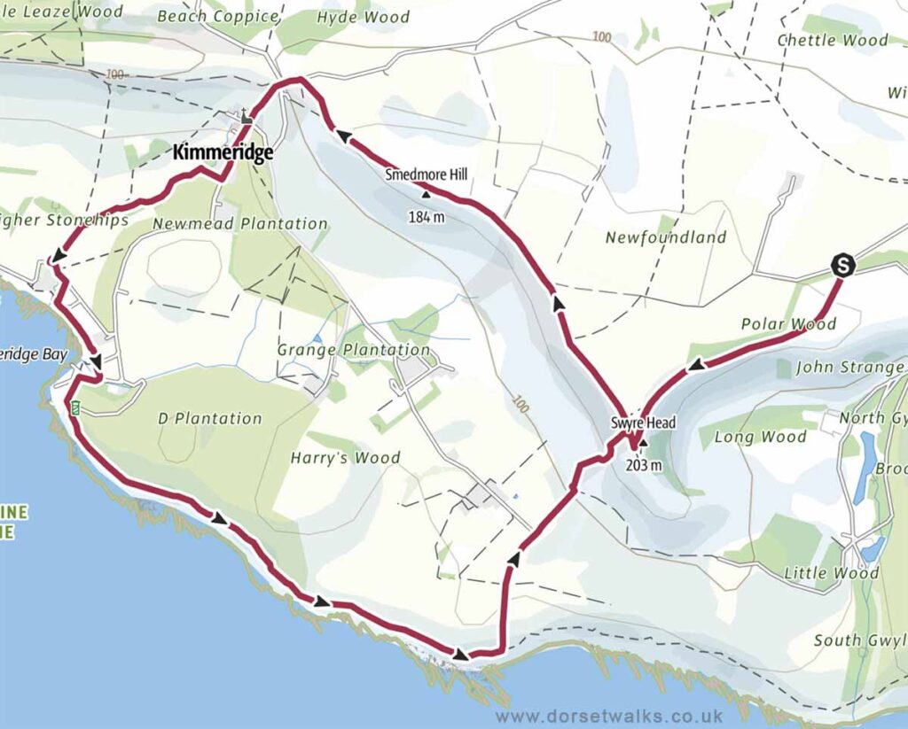
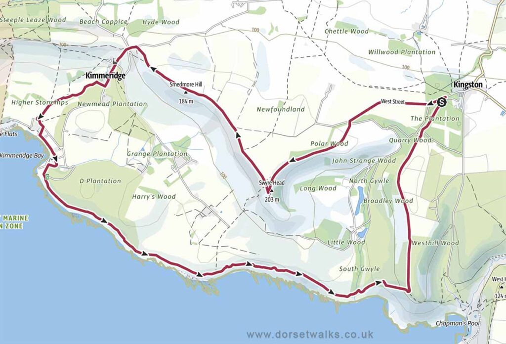
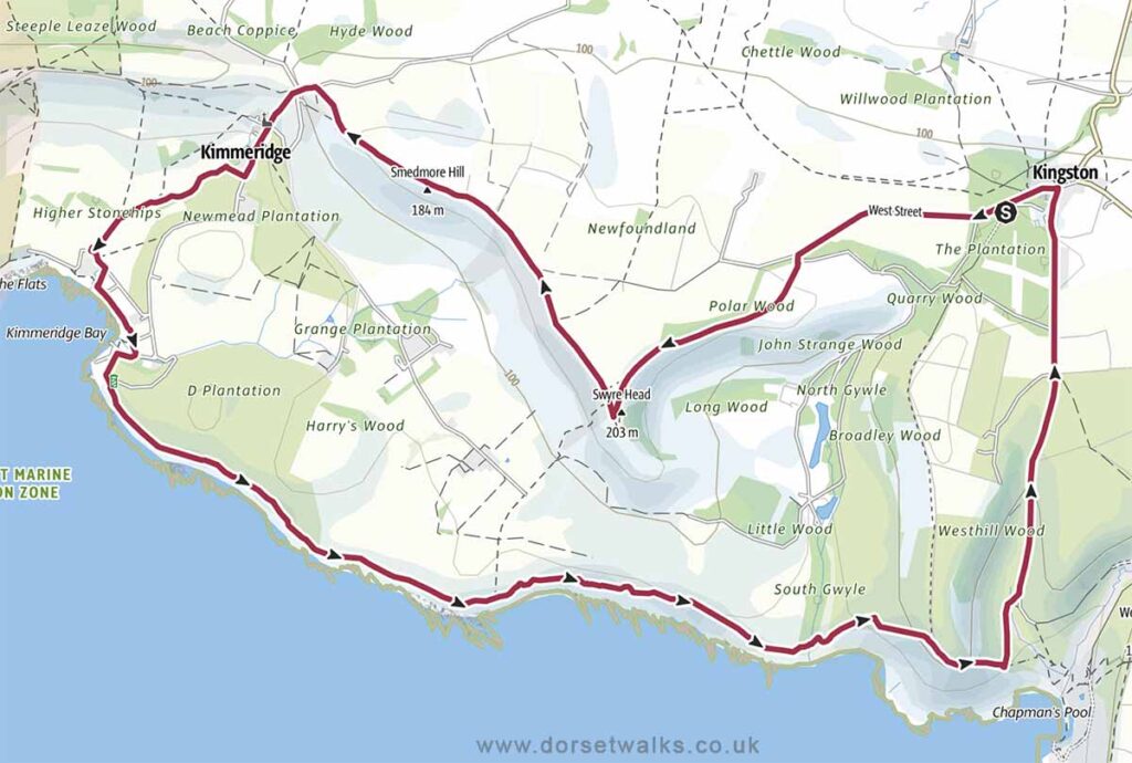
2. Kingston to Swyre Head and Kimmeridge Walk
Distance: 6.9 miles (circular)
Difficulty: Easy
Estimated time: 3 hours 25 minutes
Total ascent 856 ft, Highest point 667 ft
Starting point: Sheep Pens Car Park BH20 5LP
OS Map: Explorer OL15 Purbeck & South Dorset
Link to GPS route map
https://www.outdooractive.com/
https://www.alltrails.com/
https://explore.osmaps.com/
https://www.google.com/maps/
Base map © OpenStreetMap
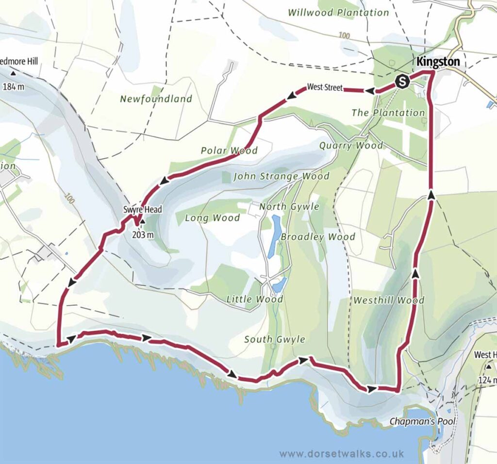
3. Kingston to Swyre Head and Chapmans Pool Walk
Distance: 5.8 miles (circular)
Difficulty: Easy
Estimated time: 3 hours
Total ascent 1161 ft, Highest point 667 ft
Starting point: Sheep Pens Car Park BH20 5LP or Houns-tout Car Park BH20 5LL
OS Map: Explorer OL15 Purbeck & South Dorset
Link to GPS route map
https://www.outdooractive.com/
https://www.alltrails.com/
https://explore.osmaps.com/
Base map © OpenStreetMap
4. Kingston to Houns-tout and Chapmans Pool Walk
Distance: 3.4 miles (circular)
Difficulty: Easy
Estimated time: 1 hours 30 minutes
Total ascent 338 ft, Highest point 522 ft
Starting point: Houns-tout Car Park BH20 5LL
OS Map: Explorer OL15 Purbeck & South Dorset
Link to GPS route map
https://www.outdooractive.com/
https://www.alltrails.com/
https://explore.osmaps.com/
https://www.google.com/maps/
Base map © OpenStreetMap
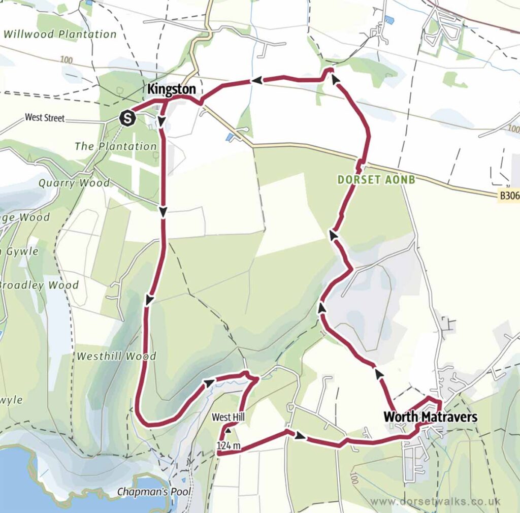
5. Kingston to Chapmans Pool and Worth Matravers Walk
Distance: 6.5 miles (circular)
Difficulty: Easy
Estimated time: 2 hours 55 minutes
Total ascent 659 ft, Highest point 502 ft
Starting point: Houns-tout Car Park BH20 5LL
OS Map: Explorer OL15 Purbeck & South Dorset
Link to GPS route map
https://www.outdooractive.com/
https://www.alltrails.com/
https://explore.osmaps.com/
https://www.google.com/maps/
Base map © OpenStreetMap
6. Kingston to Kimmeridge and Houns-tout Walk
Distance: 9 miles (circular)
Difficulty: Easy to Moderate
Estimated time: 4 hours 25 minutes
Total ascent 1030 ft, Highest point 667 ft
Starting point: Sheep Pens Car Park BH20 5LP or Houns-tout Car Park BH20 5LL
OS Map: Explorer OL15 Purbeck & South Dorset
Link to GPS route map
https://www.outdooractive.com/
https://www.alltrails.com/
https://explore.osmaps.com/
https://www.google.com/maps/
Base map © OpenStreetMap
7. Kingston to Kimmeridge and Chapmans Pool Walk
Distance: 9.5 miles (circular)
Difficulty: Moderate
Estimated time: 4 hours 50 minutes
Total ascent 1302 ft, Highest point 667 ft
Starting point: Sheep Pens Car Park BH20 5LP or Houns-tout Car Park BH20 5LL
OS Map: Explorer OL15 Purbeck & South Dorset
Link to GPS route map
https://www.outdooractive.com/
https://www.alltrails.com/
https://explore.osmaps.com/
https://www.google.com/maps/
Base map © OpenStreetMap
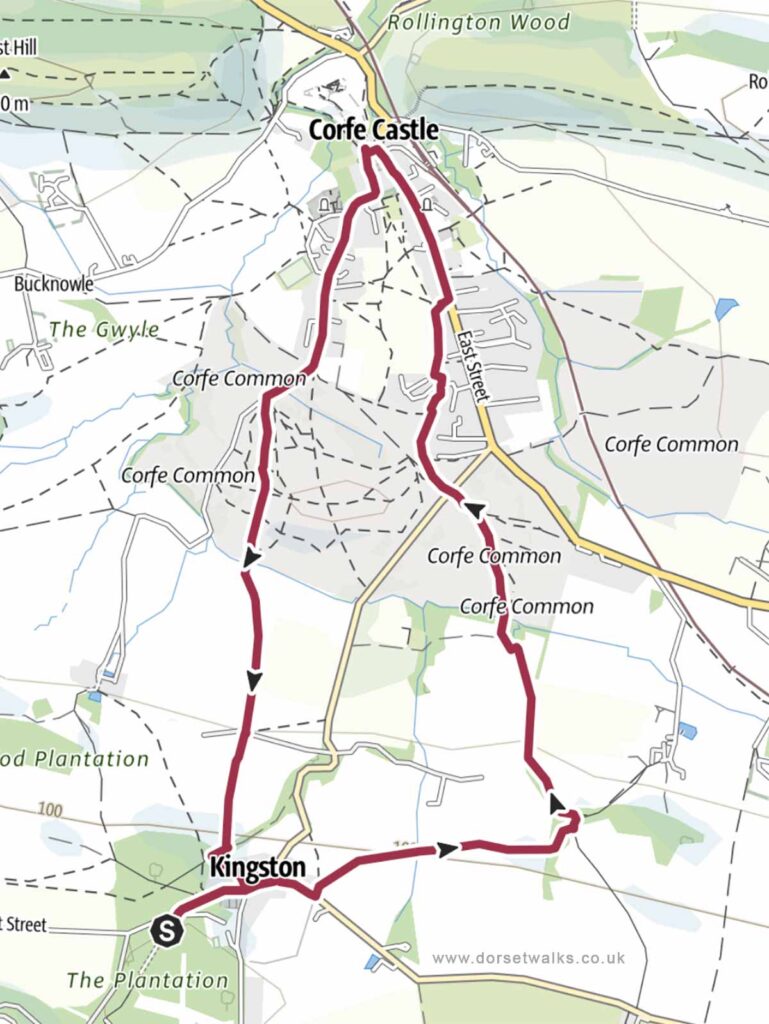
8. Kingston to Corfe Castle Walk
Distance: 4.6 miles (circular)
Difficulty: Easy
Estimated time: 2 hours
Total ascent 404 ft, Highest point 472 ft
Starting point: Houns-tout Car Park BH20 5LL
OS Map: Explorer OL15 Purbeck & South Dorset
Link to GPS route map
https://www.outdooractive.com/
https://www.alltrails.com/
https://explore.osmaps.com/
https://www.google.com/maps/
Base map © OpenStreetMap
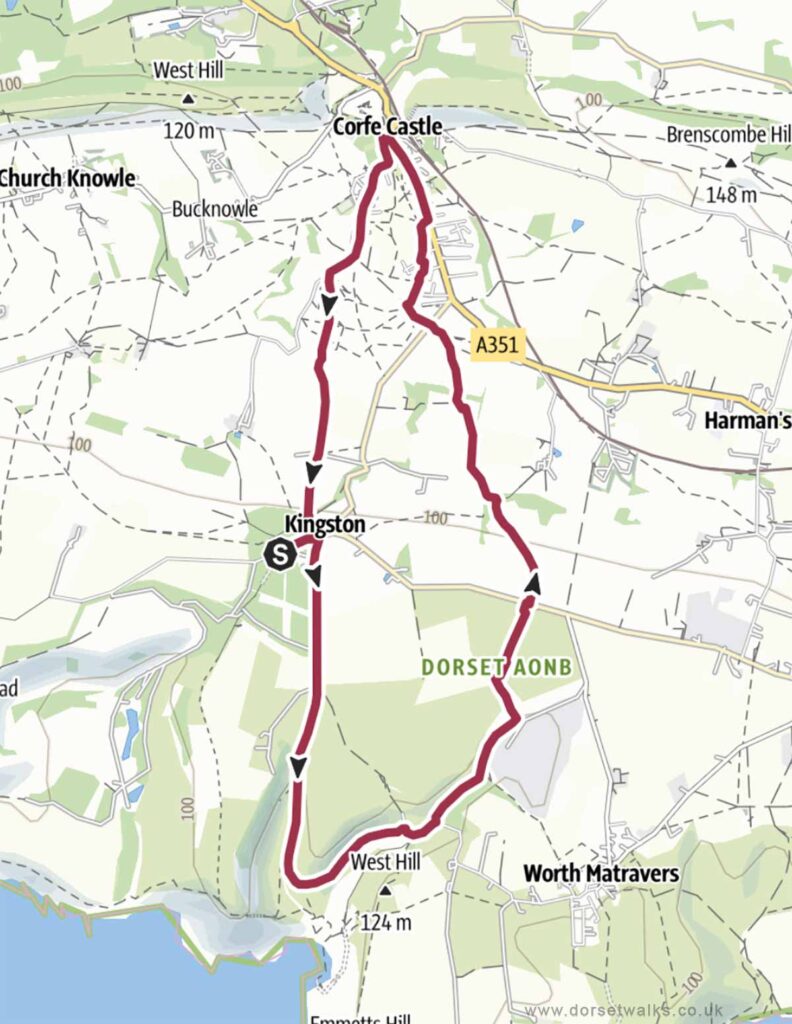
9. Kingston to Chapmans Pool and Corfe Castle Walk
Distance: 7.3 miles (circular)
Difficulty: Easy
Estimated time: 3 hours 15 minutes
Total ascent 692 ft, Highest point 502 ft
Starting point: Houns-tout Car Park BH20 5LL
OS Map: Explorer OL15 Purbeck & South Dorset
Link to GPS route map
https://www.outdooractive.com/
https://www.alltrails.com/
https://explore.osmaps.com/
https://www.google.com/maps/
Base map © OpenStreetMap
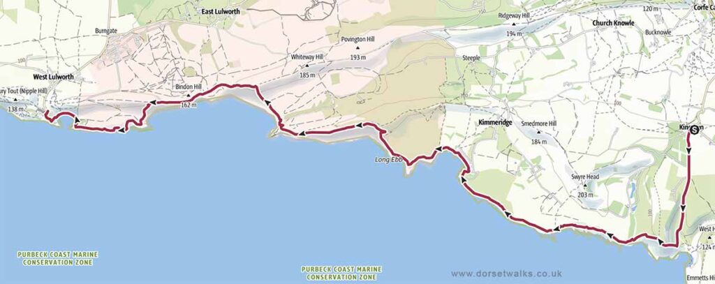
10. Kingston to Lulworth Cove Walk (SWCP)
Distance: 12.4 miles (circular)
Difficulty: Difficult
Estimated time: 7 hours
Total ascent 2444 ft, Highest point 561 ft
Starting point: Houns-tout Car Park BH20 5LL
OS Map: Explorer OL15 Purbeck & South Dorset
The section of the South West Coast Path between the east of Lulworth Cove and the west of Kimmeridge lies within the Lulworth Firing Range and can only be visited when the range is open which is usually at weekends and school holidays. However, to avoid disappointment, it’s always best to check opening dates in advance on the government website https://www.gov.uk/
Link to GPS route map
https://www.outdooractive.com/
https://www.alltrails.com/
https://explore.osmaps.com/
https://www.google.com/maps/
Base map © OpenStreetMap
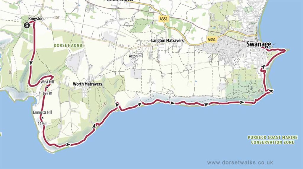
11. Kingston to Swanage Walk (SWCP)
Distance: 11.3 miles (circular)
Difficulty: Difficult
Estimated time: 6 hours 35 minutes
Total ascent 2349 ft, Highest point 502 ft
Starting point: Houns-tout Car Park BH20 5LL
OS Map: Explorer OL15 Purbeck & South Dorset
Link to GPS route map
https://www.outdooractive.com/
https://www.alltrails.com/
https://explore.osmaps.com/
https://www.google.com/maps/
Base map © OpenStreetMap
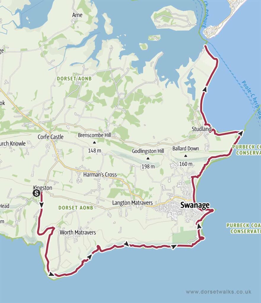
12. Kingston to South Haven Point (SWCP)
Distance: 18.8 miles (circular)
Difficulty: Difficult
Estimated time: 10 hours 15 minutes
Total ascent 3343 ft, Highest point 502 ft
Starting point: Houns-tout Car Park BH20 5LL
OS Map: Explorer OL15 Purbeck & South Dorset
Link to GPS route map
https://www.outdooractive.com/
https://www.alltrails.com/
https://explore.osmaps.com/
https://www.google.com/maps/
Base map © OpenStreetMap