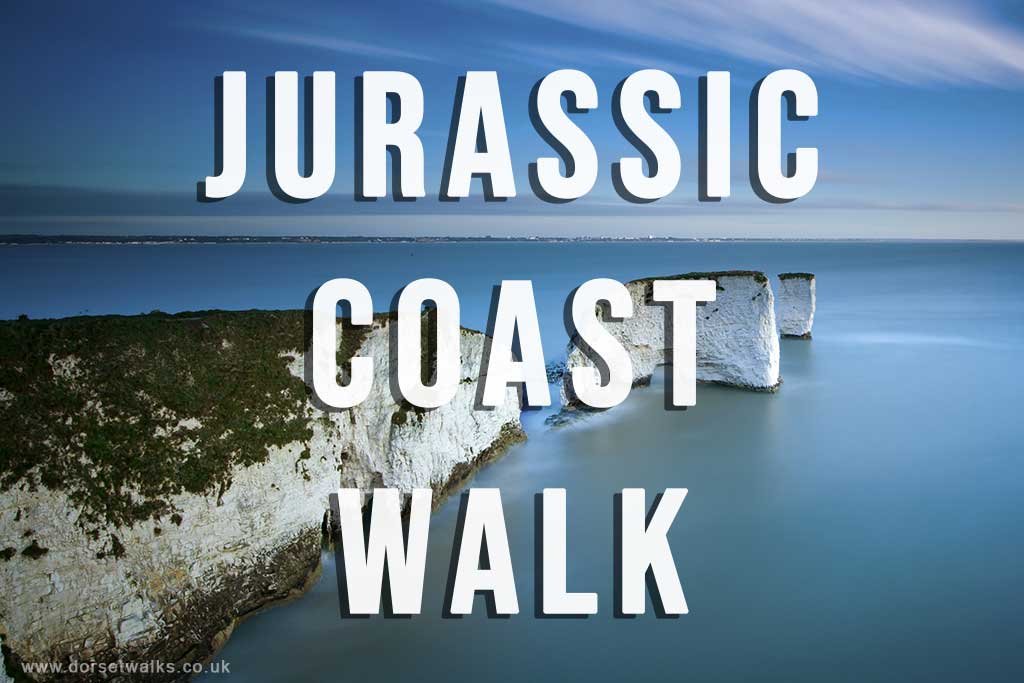
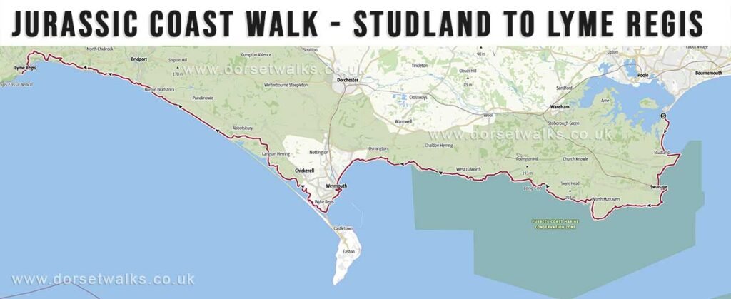
The Jurassic Coast Walk on this website follows the Dorset section of the South West Coast Path between Lyme Regis and Studland. This stretch of coastline is approximately 74 miles (119 km) in length and can be divided into manageable daily stages.
Unlike most guidebooks, which describe the route from west to east, this guide follows the path in an east to west direction. This approach has a practical advantage, particularly for multi-day walks, as the early morning sun is generally behind you rather than directly ahead. It also creates a more natural sense of progression along the coastline.
The Jurassic Coast is one of the most impressive coastal walks in the UK and is widely regarded as one of the finest long-distance coastal routes in Europe. The scenery is consistently varied, ranging from chalk cliffs and headlands in the east to the more rugged and undulating terrain further west. However, the walk can be physically demanding, with frequent ascents and descents and several longer, more exposed sections.
Planning multi-day walks along this route can be challenging due to the limited number of convenient overnight stops directly on the path. Wild camping offers greater flexibility but requires carrying additional equipment and is only permitted with the landowner’s permission.
The route described on this page covers the coastal path only. It does not include detours to and from accommodation, which may be necessary depending on where you choose to stay.
Route Overview
Distance: 74 miles (119 km)
Route: Studland (Sandbanks Ferry) to Lyme Regis (covered east to west on this site)
Stages: 9 walking stages
Difficulty: Moderate to difficult
Terrain: Cliff-top paths, steep ascents and descents, coastal tracks, shingle beaches and short road sections
Navigation: Generally well waymarked as part of the South West Coast Path, but some remote sections require careful navigation
Start / Finish: Studland (Sandbanks Ferry) to Lyme Regis (The Cobb)
Highlights: Studland Bay beaches, Old Harry Rocks, Swanage, Durlston Head, St Aldhelm’s Head, Kimmeridge Bay, Lulworth Cove, Durdle Door, White Nothe, Chesil Beach, Golden Cap, West Bay cliffs, Lyme Regis
This section of the South West Coast Path is characterised by constant variation in landscape and terrain. The eastern sections across the Purbeck Hills involve frequent elevation and exposed cliff-top walking, while the central section around Weymouth and Chesil Beach is flatter but more open and exposed to the elements. The western stages towards Seatown and Lyme Regis return to steeper gradients, culminating in the ascent of Golden Cap, the highest point on the south coast.
Although distances between stages are manageable, the cumulative ascent makes several days more demanding than they appear on paper. Careful planning is required, particularly where accommodation options are limited and access to the route involves short inland diversions.
Table of Distances and Key Route Stops
The table below outlines the key route stops along the Jurassic Coast Walk, together with stage distances and cumulative mileage. These points provide logical start and finish locations for each section of the route.
Distances are approximate and based on the South West Coast Path. Walking times will vary depending on terrain, conditions and overall pace.
| Miles | Miles (cumulative) | |
| Studland (Ferry) | 0 | 0 |
| Swanage (Square) | 7.6 | 7.6 |
| Worth Matravers (Winspit) | 6.2 | 13.8 |
| Kimmeridge | 7.3 | 21.1 |
| Lulworth Cove | 7.2 | 28 |
| Osmington Mills | 6.2 | 34.2 |
| Weymouth (Ferrybridge) | 8.1 | 42.3 |
| Abbotsbury (Swannery) | 10.8 | 53.1 |
| West Bexington | 3.4 | 56.5 |
| Burton Bradstock | 3.3 | 59.8 |
| West Bay | 2.3 | 62.1 |
| Eype | 1.3 | 63.4 |
| Seatown | 1.8 | 65.2 |
| Charmouth | 5 | 70.2 |
| Lyme Regis | 3.1 | 73.3 |
Jurassic Coast Walk Itinerary
The itinerary below breaks the Jurassic Coast Walk into a series of manageable stages. Each section includes distance, ascent and route details together with a map for planning.
Distances are based on the South West Coast Path and should be used as a guide only.
Studland to Swanage
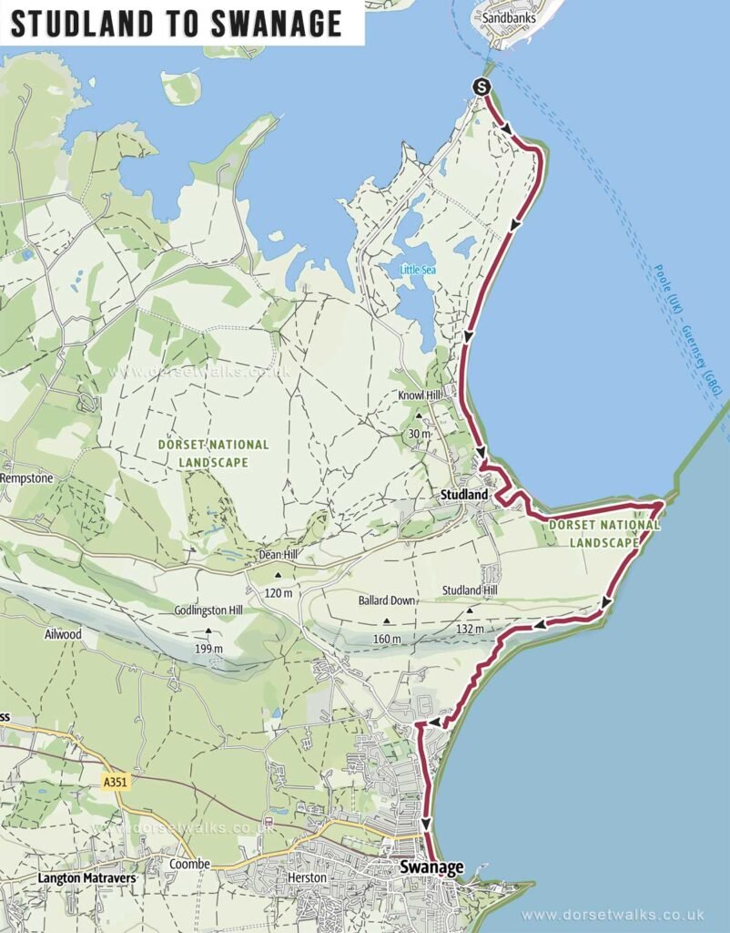
Distance: 7.6 miles / 12.2 km
Difficulty: Moderate
Estimated time: 3 hours 40 minutes
Total ascent: 955 ft
Starting point: Sandbanks Ferry
Finish Point: The Square, Swanage
OS Map: Explorer OL15 Purbeck & South Dorset
Route: Sandbanks Ferry (Studland Peninsula) – South West Coath Path marker – Shell Bay Beach – Studland Beaches & Bay – Fort Henry – Studland Village (Bankes Arms pub) – Old Harry Rocks – Ballard Point – Swanage Promenade / beach – Swanage Square
Description: A varied opening stage combining beach walking and cliff-top paths, with wide views across Swanage Bay. The highlight is the approach to Old Harry Rocks, one of the most distinctive landmarks on the Dorset coast, followed by an easy descent into Swanage.
Link to GPS route map
https://www.outdooractive.com/
Swanage to Worth Matravers
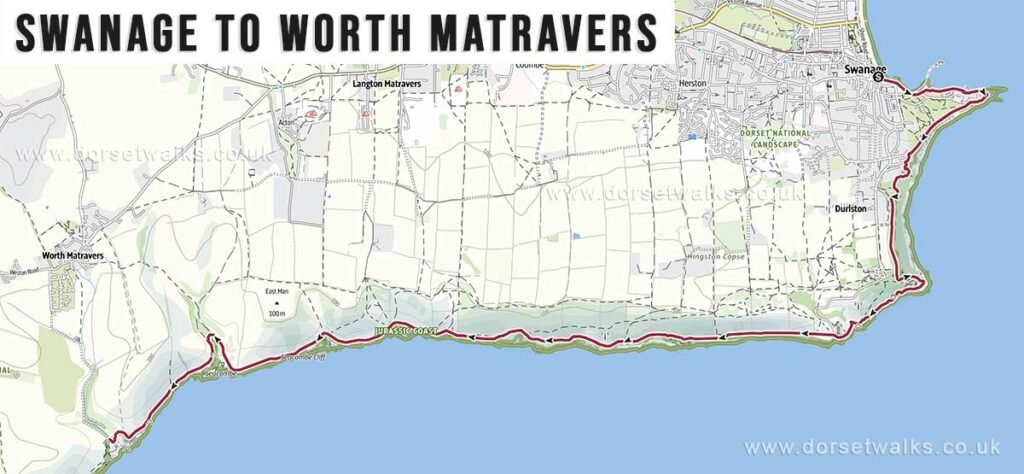
Distance: 6.2 miles / 10 km
Difficulty: Moderate
Estimated time: 3 hours 15 minutes
Total ascent: 958 ft
Starting point: The Square, Swanage
Finish Point: Winspit Quarry, Worth Matravers
OS Map: Explorer OL15 Purbeck & South Dorset
Route: Swanage Square – Peveril Point – Durlston Head – Durlston Country Park – Anvil Point Lighthouse – Dancing Ledge – Seacombe Cliff / Quarry – Winspit Quarry
Description: A varied cliff-top walk passing Durlston Country Park, the lighthouse and Dancing Ledge, finishing with a more rugged and dramatic feel around Winspit Quarry.
Link to GPS route map
https://www.outdooractive.com/
Worth Matravers to Kimmeridge
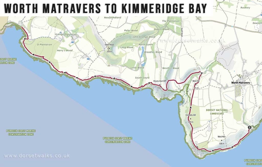
Distance: 7.3 miles / 11.7 km
Difficulty: Moderate
Estimated time: 3 hours 45 minutes
Total ascent: 1,250 ft
Starting point: Winspit Quarry (Worth Matravers)
Finish Point: Kimmeridge Bay (car park)
OS Map: Explorer OL15 Purbeck & South Dorset
Route: Winspit Quarry (Worth Matravers) – St Aldhelm’s Head – Emmetts Hill – Chapman’s Pool – Houns-tout – Kimmeridge Ledges – Clavell Tower – Kimmeridge Bay
Description: One of the wildest sections of the Purbeck coast, with exposed high ground, big sea views and a memorable run past St Aldhelm’s Head, Chapman’s Pool and Clavell Tower.
Link to GPS route map
https://www.outdooractive.com/
Kimmeridge to Lulworth Cove
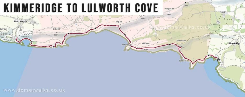
Distance: 7.2 miles / 11.6 km
Difficulty: Moderate
Estimated time: 4 hours 20 minutes
Total ascent 1,549 ft
Starting point: Kimmeridge Bay (car park)
Finish Point: Lulworth Cove (Visitor Centre)
OS Map: Explorer OL15 Purbeck & South Dorset
IMPORTANT: This walk passes through a military firing range and is private Ministry of Defence land. The range is closed to the public during the week and usually only open at weekends and holidays. It is important to check current opening times at https://www.gov.uk/government/publications/lulworth-firing-notice
Route: Kimmeridge Bay – Tyneham Cap – Tyneham Village (optional detour) – Wobarrow Bay – Arish Mell – Mupe Bay – Fossil Forest – Lulworth Cove Beach – Stair Hole – Lulworth Cove Visitors Centre. Note that the last section of the walk follows Lulworth Cove Beach rather than the official SWC Path which takes a long detour over the hill before entering Lulworth Cove from the north.
Description: A spectacular but more restricted stage across the Lulworth Ranges, with remote bays, Tyneham scenery and some of the most dramatic coastal landscapes on the route. Check range access before setting out.
Link to GPS route map
https://www.outdooractive.com/
Lulworth Cove to Osmington Mills
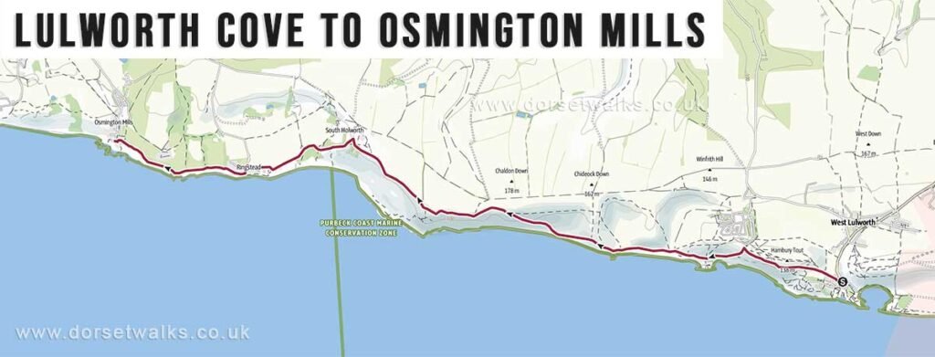
Distance: 6.2 miles / 10 km
Difficulty: Moderate
Estimated time: 3 hours 20 minutes
Total ascent: 1,463 ft
Starting point: Lulworth Cove Visitors Centre
Finish Point: The Smugglers Inn, Osmington Mills
OS Map: Explorer OL15 Purbeck & South Dorset
Route: Lulworth Cove – Man O’ War Bay – Durdle Door – White Nothe – Burning Cliff – Ringstead – Osmington Mills
Description: A classic Jurassic Coast section passing Durdle Door, Man O’ War Bay and White Nothe, with steep climbs and expansive views over this famous stretch of coastline.
Link to GPS route map
https://www.outdooractive.com/
Osmington Mills to Weymouth (Ferrybridge)
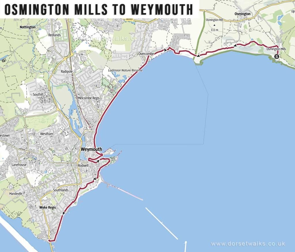
Distance: 8.1 miles / 13 km
Difficulty: Moderate
Estimated time: 3 hours 25 minutes
Total ascent: 443 ft
Starting point: The Smugglers Inn, Osmington Mills
Finish Point: Ferryman’s Way, Ferrybridge, Weymouth
OS Map: Explorer OL15 Purbeck & South Dorset
Route: Osmington Mills (Smugglers Inn) – Bowleaze Cove – Weymouth Bay & seafront – Weymouth Harbour – The Nothe – Castle Cove – Sandsfoot Castle (remains) – Chesil Beach (Ferrybridge)
Description: Easier going overall than some of the earlier stages, with gentler gradients, open coastal views and a gradual approach towards Weymouth and the Fleet Lagoon.
Link to GPS route map
https://www.outdooractive.com/
Weymouth to Abbotsbury
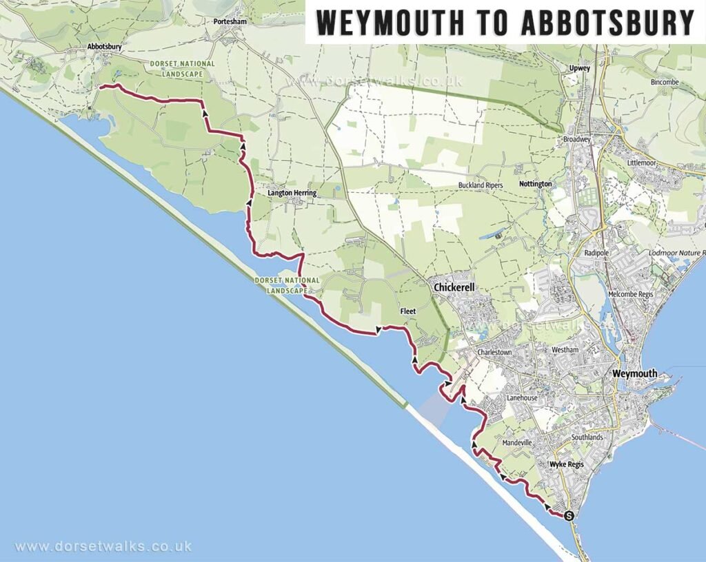
Distance: 10.8 miles / 17.4 km
Difficulty: Difficult
Estimated time: 4 hours 30 minutes
Total ascent: 472 ft
Starting point: Ferryman’s Way, Ferrybridge, Weymouth
Finish Point: Abbotsbury Swannery car park, Abbotsbury
OS Map: Explorer OL15 Purbeck & South Dorset
Route: Weymouth (Ferrybridge) – Chickerell Hive Point – East Fleet – Chesil Bank – Moonfleet Manor – Wyke Wood – Abbotsbury Swannery (car park)
Description: A longer and more exposed walk alongside Chesil Beach and the Fleet Lagoon, with a more open, windswept character than the cliff sections further east.
Link to GPS route map
https://www.outdooractive.com/
Abbotsbury to Seatown
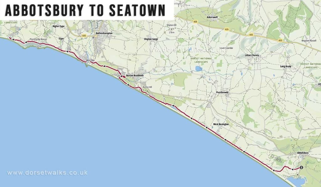
Distance: 12.1 miles / 19.5 km
Difficulty: Difficult
Estimated time: 5 hours 15 minutes
Total ascent: 1,073 ft
Starting point: Abbotsbury Swannery car park, Abbotsbury
Finish Point: Anchor Inn, Seatown
OS Map: Explorer OL15 Purbeck & South Dorset
Route: Abbotsbury (Swannery car park) – Chesil Beach – West Bexington – Hive Beach (Burton Bradstock) – West Bay – Eype Mouth – Thorncombe Beacon – Seatown
Description: A rewarding long-distance stage combining Chesil Beach, West Bexington, Burton Bradstock, West Bay and a stronger hill-walking feel towards Thorncombe Beacon and Seatown.
Link to GPS route map
https://www.outdooractive.com/
Seatown to Lyme Regis
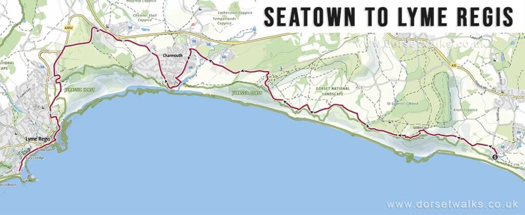
Distance: 8.1 miles / 13 km
Difficulty: Difficult
Estimated time: 4 hours 10 minutes
Total ascent: 1,693 ft
Starting point: Anchor Inn, Seatown
Finish Point: The Cobb, Lyme Regis
OS Map: Explorer OL15 Purbeck & South Dorset
Route: Seatown (Anchor Inn) – Golden Cap – Stonebarrow Lane – Charmouth – Lyme Regis Golf Club – Lyme Regis (The Cobb)
Description: A demanding final stage with major ascent, big views from Golden Cap and a dramatic finish above Lyme Bay before descending into Lyme Regis.
Link to GPS route map
https://www.outdooractive.com/